Measuring RoutesHow is your route measured?
MEASURING RUNNING ROUTESDifferent Methods of Route Measurement 1. Jones CounterThis is the benchmark for accurate measurement of running routes and is the method used to certify the accuracy of many UK and International races. A Jones Counter is a small device attached to a bicycle wheel that measures distance by counting the revolutions, or partial revolutions, of the wheel. It is calibrated for use on a specific bike using a perfectly straight calibration course. Jones Counters normally produce measurements that are accurate to within 0.1%. You can find out more at the UK Road Running Course Measurement site. Benefits: The most accurate! Cons: Not exactly practical for the average runner! 2. Online route measurerOur Route Measurer on Good Run Guide uses Google maps satellite images. This works by determining the latitude and longitude coordinates of each point plotted on the map and then using a distance formula to calculate the distance between each point.
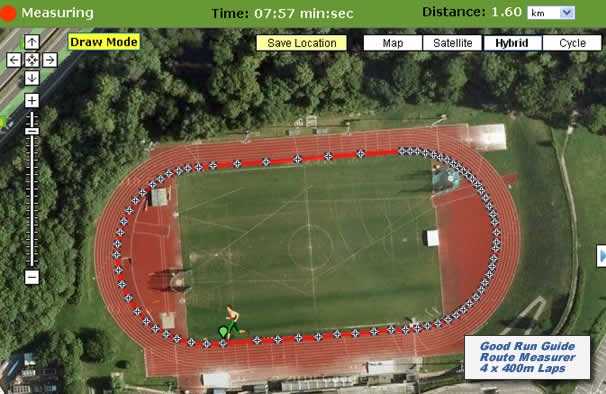
To test the accuracy of our Route Measurer, we measured four laps of a 400m athletics track using the satellite map view (see illustration below) and repeated the exercise 20 times. The results varied by only 0.32%, with measurements ranging from 1598.344m to 1603.518m. On all occasions, measurements were within 0.22% of the correct length with the majority being within 0.1%. To achieve good accuracy levels though, it is essential to plot points carefully, ideally while zoomed in to the maximum extent.
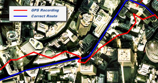
Benefits: Can be very accurate. No worries about a loss of signal in built up/wooded areas Cons: You need to measure before or after your run and need to run exactly the same route 3. GPS Receivers/Watches/GPS AppsGPS devices work by measuring the time taken for signals to be received from a network of 24 satellites in space. They work best when they have a clear view of the sky and need to ‘lock on’ to at least 3 satellites to work out your position. They can also work out your height above sea level in a similar way but need to lock on to at least 4 satellite signals to do this. Unfortunately GPS devices are not infallible. Even with a clear view of the sky, each individual position that is recorded is typically only accurate to between 3 and 5 metres, which can add up to quite a high potential error over a long route. Garmin watches If you have one of these be sure to sync it with GRG so that your runs/routes are automatically sent through to your log book. Garmin devices are more expensive compared to using mobile apps, but they are very convenient and have lots of added extras. As well as measuring your run, they record where you ran (not where you think you ran), and can also track your heart rate and other variables depending on which model you choose. They also provide great instant feedback. But unfortunately GPS devices such as Garmin devices are not infallible. Even with a clear view of the sky, each individual position that is recorded is typically only accurate to between 3 and 5 metres, which can add up to quite a high potential error over a long route. Even greater errors can occur when recording your height above sea level. The biggest GPS inaccuracies tend to occur in built up or densely wooded areas, as the signal can be delayed or prevented from reaching the GPS device. However, even in the open, devices are subject to errors from variations in atmospheric conditions. When a GPS signal is lost altogether, it results in the last two known positions being joined with a straight line, effectively cutting off any corners in between and producing a short measurement. When signals are reflected off buildings, straight paths can be recorded with kinks, thereby resulting in a long measurement. To illustrate this, the following picture shows an example of a section of a route recorded by a runner using a GPS device in central London.
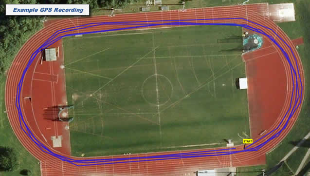
We conducted a controlled test to assess the accuracy levels of popular running GPS devices. The test was carried out on two different open air athletics tracks, each with a clear view of the sky, using two modern GPS devices. Two runners recorded 20 separate measurements of a 1600m route by running four 400m laps of the track. The results varied by 7.4%, with measurements ranging from 1571.693m to 1734.660m. Most measurements were within 4% of the correct length but the most inaccurate result was 8.4% out. The following picture shows an example of one of the recordings. The runner ran around the inside lane but you can clearly see that the recorded path often deviates from the correct position by around 3 to 5 metres.
In most circumstances though, runners usually find that the level of accuracy is satisfactory for their needs. Our advice is to always check that the route has been correctly recorded using a satellite map view of the route. You can then make any adjustments as required by editing the route on the map. Benefits: easy to use with instant tracking and feedback Cons: Can be expensive and need to be kept charged Why does the distance on my Garmin not exactly the same as shown in my GRG log book after syncing? When you upload a run to Garmin Connect it will automatically send the tracking points, time and heart rate (if relevant) through to us. We then instantaneously generate the tracked route in your log book, and we use our algorithm to calculate the distance between the points. This distance occassionally varies from a small amount to that reported by Garmin. Howver, we believe our algorithm is extremely accurate as it is calculated as per our route measurer. We also instantaneoulsy search for any of your previously mapped routes to see if they match the new route (within a small tolerance of each of the tracked points). If it does then we change the route very slightly to match exactly and rename the route to your original name. This enables you to compare all your times for your routes and also log any PB's. So, this can be another reason why the distance on your Garmin may not be exactly the same as in your GRG log book. Mobile Apps These are not surprisingly very popular as they are generally cost free (unless you sign up to the often offered premium service). They use the same GPS tracking as GPS watches , with the same benefits and cons on the tracking front. However the GPS accuacy does depend on how accurate the GPS in your phone is. At present there is no automatic sync from these apps to the GRG log book, but you can often download your activities as TCX or FIT files and then import to your log book. See here (link to https://www.goodrunguide.co.uk/UploadGPS.asp) Benefits: Low cost and easy to use with instant tracking and feedback Cons: Rely on accuracy of GPS in the phone. Often don't give the same level of information as a GPS watch.
Overall tips for accuracyIf plotting a route on our Google Maps Route Measurer
If recording a route using a GPS:
What level of accuracy will I get?Whatever method of measurement you use, it is virtually impossible to measure the exact difference. As a result, it is not unusual to get slightly different measurements each time for the same route and also a small difference if using more than one means of measurement. GPS is nowdays is very good, but not infallible and it depends on the number of points recorded, how the distance between them is calculated and whether a signal was sustained
|


 Good Run Guide - The UK's Leading Independent Running Website